 |
Program complex "Vega-Kontur"
Processing of information received by Earth remote sensing systems
Part number:
Description
Key features:
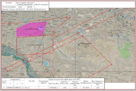
- display of specific and radio technical information on the background of continuous geospatial coatings based on SXF and S57 maps, BSPVR, maps and coatings of open formats (Google, OSM);
- A flexible database structure that allows the free formation of a user data model with attributes and display semantics;
- joint storage of operational-tactical and specific information in the database;
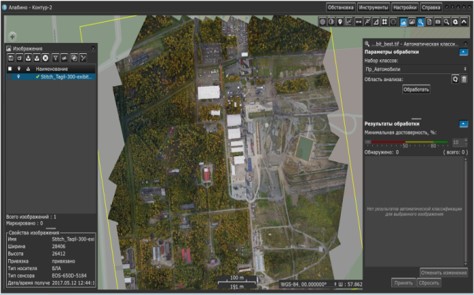
- A full range of photogrammetric processing of specific information, support for most EPSG projections;
- automatic detection and classification of objects of given types and classes according to specific information using deep learning neural networks;
- training tools for neural networks (optional);
- formalization of formats of output documents (from program interaction to a paper document) to customer requirements and automation of the process of their preparation;
- interfacing with information sources using special software interface modules (SMPS) with an open software interface;
- multi-user mode of operation (dedicated server and client components);
- automatic stitching, specification of the binding of species information.
- display of specific and radio technical information on the background of continuous geospatial coatings based on SXF and S57 maps, BSPVR, maps and coatings of open formats (Google, OSM);
- A flexible database structure that allows the free formation of a user data model with attributes and display semantics;
- joint storage of operational-tactical and specific information in the database;
- A full range of photogrammetric processing of specific information, support for most EPSG projections;
- automatic detection and classification of objects of given types and classes according to specific information using deep learning neural networks;
- training tools for neural networks (optional);
- formalization of formats of output documents (from program interaction to a paper document) to customer requirements and automation of the process of their preparation;
- interfacing with information sources using special software interface modules (SMPS) with an open software interface;
- multi-user mode of operation (dedicated server and client components);
- automatic stitching, specification of the binding of species information.